
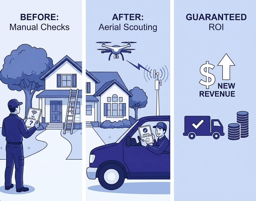
Move Beyond Predictions and Manual Checks
Aerial Scouting Secures Perfect Signal
Guaranteed ROI on Every Roll: because the drone has already verified the signal and the exact hardware needed, every single truck deployment results in a paying customer. The field team stops wasting money and starts exclusively finalizing sales.
Unlocking "Hidden" Revenue: ground crews often mark difficult homes as "unserviceable" because they can't safely or easily find a signal from a ladder. The drone finds signals ground crews miss (by checking higher altitudes or different angles), instantly turning a "no" into new monthly recurring revenue.
Faster Velocity: by knowing exactly where to install and what equipment to bring, install times drop dramatically. The same number of staff now generates significantly more revenue.
Most importantly: keep technicians on the ground until the location is verified. Eliminate unnecessary climbing and the risk of repositioning ladders or trucks multiple times.
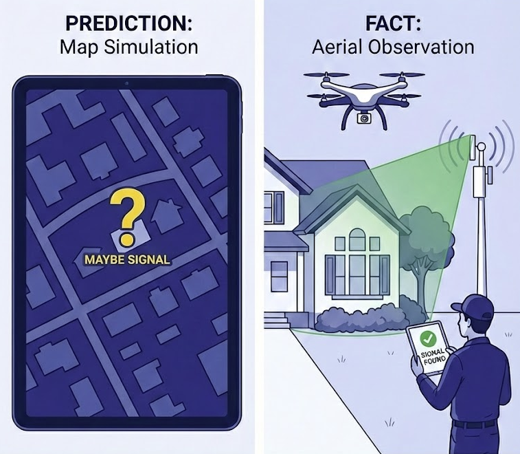
Prediction Is Not Fact
Observations Reveal Ground Truth
We spent over a decade developing software to simulate radio signal propagation and we know the hard truth: a prediction is not a physical fact. Even the best algorithms meet the harsh reality: terrain data becomes outdated the moment it's collected, and modeling is inherently a simplification of the real world.
We know exactly how frustrating it is when the data says there should be a signal, but your truck rolls back with a failed install.
That’s why we are developing RFmetric: to bridge the critical gap between your planning software and the physical world. By combining drone flight with precision signal analysis, we help verify leads and pinpoint reachable signals where manual crews struggle.
Transform Field Operations to Growth Engine
Choose Verification: Visual to Automated
TrueLOS Visual
"See What the Software Can't." Verify Line of Sight (LOS) instantly. The drone automatically directs its camera toward the tower, so you don't have to hunt for it. The rule is simple: if you can see the site on your screen, you have confirmed LOS.
Airborne Signal Emulation
"Mimic the Install in Mid-Air." Don't just guess—test with real hardware. Mount your specific CPE (Customer Premises Equipment) on our stabilized gimbal. The system automatically aligns the antenna with the tower to connect from the air, giving you actual signal readings (RSSI, SNR) without a technician ever leaving the ground.
Automated Flight Control
"Hands-Free Precision Scouting." Eliminate pilot error and maximize efficiency. Whether scanning a rooftop for a residential mount or rising vertically for a tower mast deployment, the software flies a precise, automated pattern to find the absolute strongest signal spot for you.
Turn Unserviceable Homes Into Subscribers

Identify Potential Leads. Use your existing planning software to generate coverage maps and identify target homes.
Validate & Quote Accurately. Use the drone to validate the signal and find the best install spot — if one exists. Know instantly if a customer needs a standard roof mount or a heavy-duty mast.
Deploy with the Right Gear. The install crew arrives knowing exactly where to mount and carrying the exact equipment needed — eliminating "surprise" costs and "return trips".
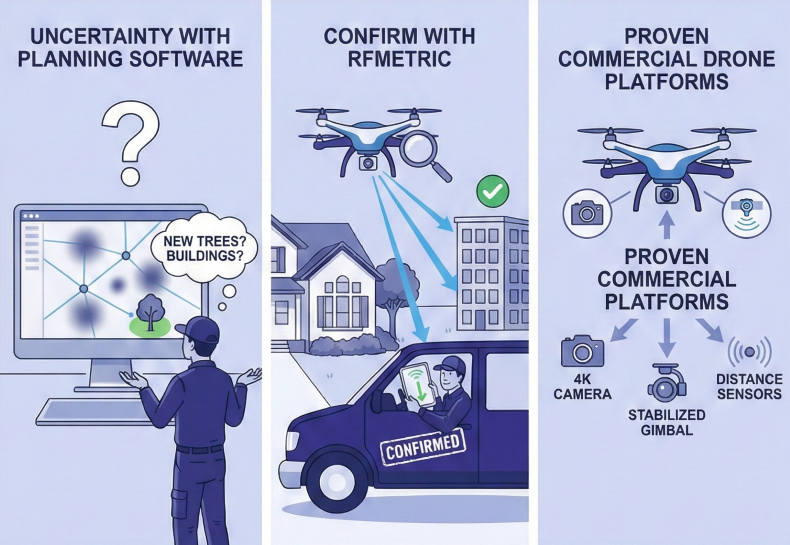
Stop Relying On Assumptions
Support Crew With Facts
Even the best planning software encounters zones where new trees or buildings create uncertainty. Use RFmetric to validate these leads before you commit a truck. Confirm the signal and determine exactly where and what is needed, so your crew arrives ready to install with absolute certainty.
We utilize proven commercial drone platforms,repurposing their high-precision components —like 4K cameras, stabilized gimbals, and distance sensors — specifically for telecommunications to ensure smooth, collision-free flights without the cost of custom hardware.
By installing our proprietary software, we transform these standard aircraft into RF scouts. Simply upload your network topology, including Access Point locations, antenna azimuths, and coverage predictions.
Because all network data is stored locally on the device, your crew can perform precise scouting and information gathering completely offline, ensuring valid results regardless of cellular coverage.
Frequently Asked Questions
As we say, 'a prediction is not a physical fact.' Even the best algorithms simplify the real world and rely on terrain data that becomes outdated quickly. RFmetric bridges the gap between software models and reality, validating leads physically to ensure you never send a crew to a 'dead' location.
Yes. Think of predictions as your map and RFmetric as your scout. You still need your planning software to identify potential leads and general coverage areas. RFmetric takes the next step: it validates those "maybes" into "definites" on a house-by-house basis, ensuring you only dispatch resources to confirmed, winnable locations.
Not necessarily. RFmetric adapts to your existing workflow in two flexible ways:
- Equip Your Installers: Your current crew flies the drone immediately upon arrival. In just a few minutes, they verify if the home is viable before unloading the ladder or climbing the roof. If there’s no signal, they move to the next job instantly, saving hours of wasted labor. Crucially, if you use bucket trucks, the drone confirms the signal from the air first—preventing you from driving heavy equipment onto a customer's lawn or damaging vegetation for a job that isn't even possible.
-
Equip a Scout or Sales Rep: Because the flight is semi-automated, you can send a surveyor or sales rep to validate leads ahead of time. This ensures your highly skilled, certified technicians and specialized trucks are only deployed to guaranteed "wins."
No, they do not need to be experts. Flying commercially is straightforward, though requirements differ slightly by region. Our software helps you stay compliant by automating flight safety limits (such as altitude and geofencing) and handles the complex flight patterns and data collection while the technician oversees the operation. This requires only basic drone piloting skills that are very easy to learn. Your current team can master the essentials quickly, ensuring they are comfortable and safe in the field without needing advanced training.
Yes, there are legal requirements, but they are manageable and designed for businesses like yours to get started quickly. You generally do not need a full "pilot's license," but you will need a basic certificate. Compliance is a standard administrative step, much like getting a driver's license but faster.
In the USA (FAA Part 107)
- At least one person on site must hold a Remote Pilot Certificate. This requires passing a multiple-choice knowledge test (Part 107) at a testing center. It focuses on safety and reading airspace maps, not flying skills.
- You must register your drone online with the FAA ($5 fee) and ensure it broadcasts a Remote ID signal (drones do that automatically).
In the European Union (EASA)
- Your company registers as a "UAS Operator" in your home country to get a unique Operator ID.
- For standard operations (Open Category), pilots must pass an online training course and exam (A1/A3 proof of competence). This is a simple online process in most member states.
Important Note: This information is intended as a general overview and may not reflect the most current or specific regulations for your exact location. Aviation laws are complex and subject to change. We strongly recommend always verifying the specific compliance requirements with your local aviation authority (FAA, EASA, or national CAA) before flying.
Absolutely. We understand that new installs often happen in no coverage zones. You upload your network (AP locations and predictions) to the device before leaving the office. All data is stored locally, allowing your crew to scout and gather information completely offline.
Yes. With our Airborne Signal Emulation, you can mount your specific CPE (Customer Premises Equipment) directly onto the drone’s gimbal. The system aligns the antenna with the tower, giving you actual signal readings (RSSI, SNR) without a technician ever leaving the ground. Note: Please contact us to verify the dimensions and weight of your specific CPE first, so we can ensure it is compatible with the drone's payload capacity.
Yes. Our TrueLOS (Visual Verification) is ideally suited for this. The drone can ascend until the remote site is visible, then descend to identify the minimum height where a clear line of sight is still maintained. This visually confirms that the path is free of obstructions - like tree lines or buildings - allowing you to determine the exact mast height needed before you attempt to build the link.
RFmetric is not yet available for commercial sale. However, we are designing the solution to be highly cost-effective—specifically, we expect the investment to be significantly lower than the operational cost of a bucket truck or the expense of a wasted truck roll. To stay updated on our progress, please select Get Product Updates or Request Early Access below to shape the final product.
Future Is the Zero-Touch ISP
Sell Broadband Like Consumer Goods
We envision a future where ordering wireless internet is as seamless as buying a book online. In this ecosystem, a customer places an order in your existing e-shop, eliminating the typical "let us check and call you back" delays. If coverage is uncertain, the system automatically triggers an RFmetric drone to conduct an autonomous scout. The result? Tailored, step-by-step mounting instructions generated specifically for that household.
The Philosophy: The Future Belongs to Self-Service
Modern consumers value speed and autonomy; waiting for an installation window is a friction point they want to avoid. If a customer can assemble flat-pack furniture, they are capable of mounting a pre-configured antenna. This means a visit to your e-shop ends with shipping equipment, not scheduling an appointment. Your highly skilled technicians and truck rolls are then reserved strictly for the most complex, non-standard challenges.
Our Role: The Verification Engine
We are not building the store or the logistics; we are building the verification engine that powers them. Our goal is to be the critical "truth layer" in your automated workflow. By integrating RFmetric, you verify the "product" (the signal) before the sale is finalized. We are preparing the technology today to fit seamlessly into this fully automated future.
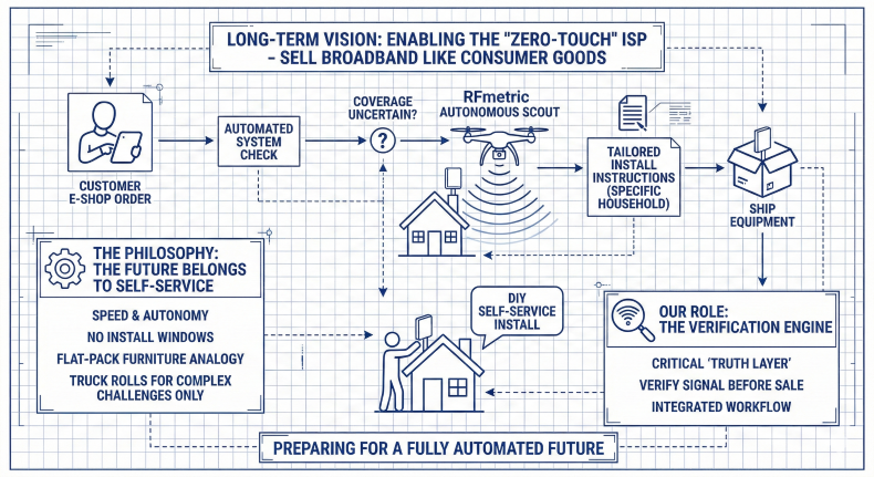
In summary: a "Zero-Touch" Internet Service Provider is one that has fully automated the entire process of acquiring a new customer and getting them connected to the internet without manual intervention.
Be First to Automate Scouting
RFmetric is not yet available for commercial sale. We are identifying a select group of internet providers to become our first launch partners.
By expressing your interest now, you secure priority access to test the system as soon as field trials begin. You will also have the opportunity to help define the final feature set — share your experience and requirements now, so we can ensure the final product solves your specific challenges.
Not ready to commit? You can simply subscribe to receive development updates.
Our Promise: we do not share your information with third parties and will not flood you with advertising. We prioritize real connections — if we contact you, it will be a direct, personal message from our team, not an automated mailing list.
RFmetric is developed in the European Union (Spaces Gedimino, 44A Gedimino Avenue, Vilnius 01110, Lithuania). While our primary focus is on the USA, Canada, and EU markets, we are open to innovation partnerships worldwide.
